
New Zealand's Most Complete Historic Aerial Imagery Search Tool Has Arrived
Finding historic aerial photography shouldn't feel like searching for a needle in a haystack.
That's why we've completely rebuilt the ASL Historic Aerial Photo Library to combine Aerial Surveys (ASL) and the Crown imagery archive (including NZAM imagery) photo centres, creating what we believe is New Zealand's most comprehensive historic aerial imagery search tool.
Whether you're an environmental consultant, planner, engineer, surveyor, historian, researcher or property professional, you can now find the aerial imagery you need faster than ever before.
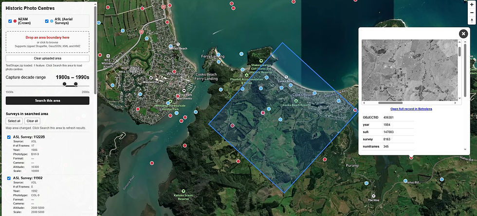
What's New?
Our new interactive map brings together decades of aerial photography into a single, easy-to-use search experience.
New features include:
Search thousands of historic aerial photo centres across New Zealand
Browse imagery by decade from the 1930s through to the 2000s
Search both Crown Imagery (includes NZAM imagery) and Aerial Surveys (ASL) archives simultaneously
Upload your project boundary (Shapefile, GeoJSON, KML or KMZ) to instantly focus your search
Preview available imagery before requesting photographs
Select multiple photo frames directly from the map and submit them as a single request
Click on photo centres to see information including, Survey, Number of frames, camera type, format, altitude and more
The Most Comprehensive Archive in New Zealand
By combining imagery from the Crown Imagery archive with the Aerial Surveys Ltd (ASL) collection, this tool provides access to the largest searchable collection of historic aerial photography available in New Zealand.
Rather than searching multiple catalogues or manually reviewing index maps, you can now locate available imagery from both collections in one place.
Built for Professionals
Historic aerial photography remains one of the most valuable datasets for understanding how our landscape has changed over time.
The new search tool helps support projects including:
Environmental monitoring
Resource consenting
Infrastructure planning
Restoration planning
Change mapping
Coastal and river change analysis
Forestry and land-use studies
Property and legal investigations
Historical research
Disaster recovery and resilience planning
Start Exploring
Whether you're investigating land-use change over the last 80 years or simply trying to locate imagery for your next project, our new Historic Aerial Photo Library makes the process faster, easier and more intuitive than ever before.
Explore New Zealand's most comprehensive historic aerial imagery search tool today and discover what's changed from above.


Comments