
Aerial Surveys Image Library. I can see my house from here!
- Jun 19, 2023
- 2 min read
Aerial Surveys is New Zealand's oldest aerial surveying business. Aerial Surveys has been capturing imagery since the 1950's. Over 70 years of capture has resulted in a large library of negatives, and since 2009, digital imagery. For the first time in 70 years were making our library of Aerial imagery searchable for all!
Those looking for aerial imagery from the past can now search both our Historic Neg Library or Digital Aerial Image Library online via our website.

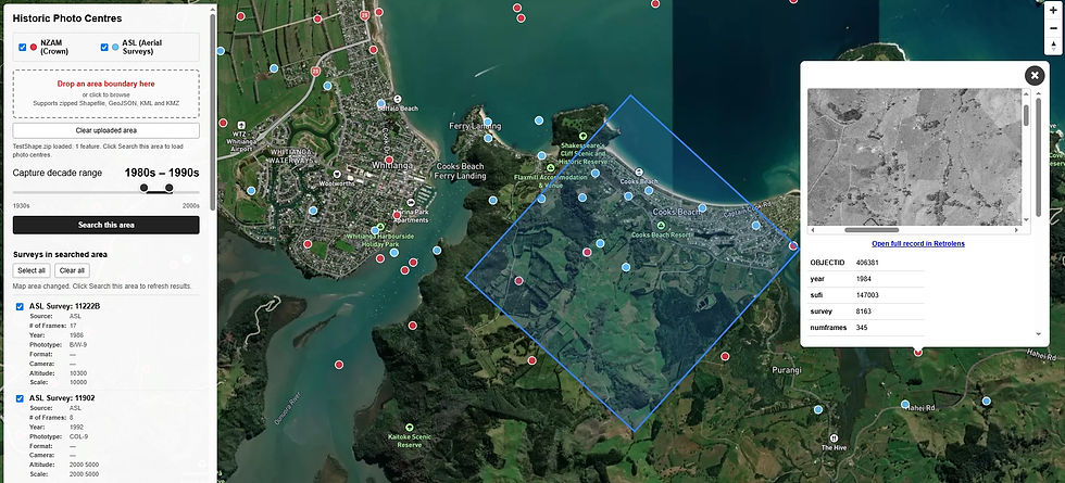
Digital Library
Aerial Surveys started using digital cameras in 2009. Digital sensors meant out of the box positional data showing exactly where this imagery was taken geographically. For those looking to search this imagery it has meant we've been able to build an interactive map showing the photo centers and frame extents. Users can now move around New Zealand and scroll through the years to see where imagery is available. The map itself is designed to be a discovery portal to see where and what is available. The imagery on the map is a satellite and road network base layer and not the actual imagery. This ensure speed of loading and navigation.

Historic Library
Aerial Surveys historic negative library is a window into the past. Never before has this been made public. Whilst we do have photo centers mapped for roughly a 3rd of the Historic library most of this imagery cannot currently be shown on a map. For those not currently mapped someone often physically needs to review the flight plan and look through the negatives to find the location requested.
To search this data Aerial Surveys has published a searchable table. Users can now search key words, regions and the year to look for relevant aerial imagery. On request aerial surveys can look out and scan imagery.
Imagery Services
Often our customers don't just need aerial imagery, but something more spatially accurate they can be used for measurement and analysis. Aerial Surveys offer services to ortho rectify even historic imagery. Services include:
Georeferenced ortho imagery (high accuracy and GIS ready)
Digital terrain modelling for ortho production and contours
Slope and aspect maps for planning purposes
High resolution ortho imagery
Topographical/feature mapping from digital imagery
Change detection mapping/time series mapping
DTM and DSM outputs for 3D modelling
True ortho imagery (removal of building lean)
Volumetric mapping to accurately quantify materials for audit and contract payment purposes
Image dense matching for generation of colourised, classified point clouds


Comments